Photo: Day 4
21.2.2015
Here you can find photographs of massif Mont Blanc from the Italian side, Matterhorn, Bernina, Bolzano, St Bernard pass, Dachstein and several more prominent Alpine mountains.


Getting the engine ready for a start in minus 5 degrees C

Quite a thick white frost had to be removed from the wings


The last refuelling on this trip - Aosta


A helicopter tried to blow OK LEX away just after refuelling


The last view of the airport at Aosta
 at the end")

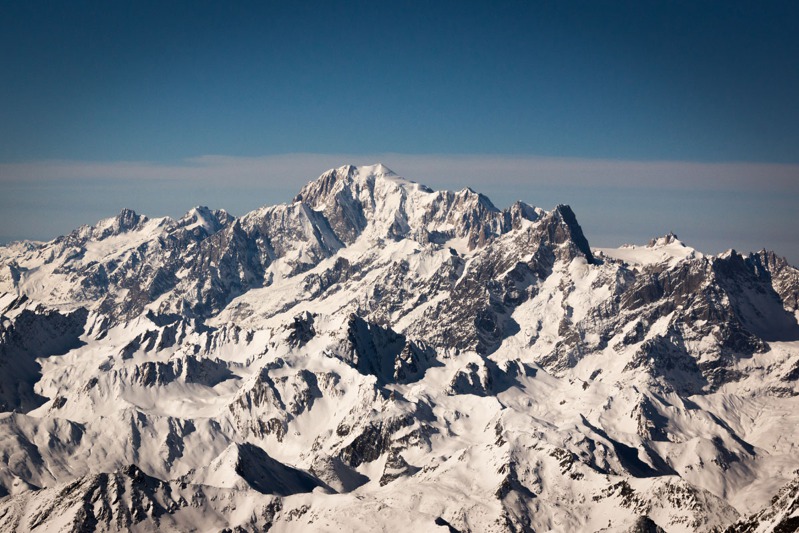
The valley of Aosta with Mont Blanc (4830 m) at the end


Dome de Goutier 4304 m, massif Mont Blanc. Two Air India aircraft crashed here


Courmayeur skiing station at the Italian side of Mont Blanc


Massif Mont Blanc towards the west


South-western part of massif Mont Blanc – Aiguilles grises left


Aiguille du Midi and Vallee Blanche over Chamonix


Upper station of the chair lift from Courmayeur to the Vallee Blanche area
 4013 m over Vallee Blanche")

Giant´t dent peak (Dent du Geant) 4013 m over Vallee Blanche
 leading up to Valléé Blanche")

Giant´s Glacier (Glacier du Geant) leading up to Valléé Blanche


Aiguille du Midi with the upper cable car station on the left


Mont Blanc 4831 - main summit from the East


Mont Maudit, 4465 m, massif Mont Blanc


Mont Blanc, 4831 m, main summit from the South


Middle part of the valley and glacier of Vallee Blanche, France


Aiguille du Midi with the upper part of Vallee Blanche skiing area


Mont Blanc du Tacul, 4248 m, with Vallee Blanche glacier


The area of Mont Blanc du Tacul peak


The valley, town and airport of Aosta
 part of St Bernard pass")

The southern (Italian) part of St Bernard pass
 part of St Bernard pass")

The northern (Swiss) part of St Bernard pass


Highway entrance to the Grand St. Bernard tunnel, Switzerland


Gallery covered highway on the Italian side of Grand St. Bernard pass

Monte Rosa, 4634 m, eastern Wallis Alps, Italy/Switzerland


Massif Grand Combin with a valley leading up to Geneva lake


Grand Combin massif, Wallis Alps


Monte Rosa, 4634 m, Wallis Alps, Switzerland


Matterhorn, 4468 m, Wallis Alps, Zermatt


Upper part of a skilift over Zermatt, Switzerland


Snow fields around Weissmies summit, 4017 m, Wallis Alps


Northern tip of Lago di Como, Italy


Piz Bernina, 4049 m, Swiss-Italian border


Piz Palu, 3901 m, Switzerland


The peaks of Piz Palu massif


Bernina pass connecting Switzerland and Italy - Italian side


Piz Palu, 3901 m, Switzerland


Monte Cevedale, 3901m, Switzerland


The valley and airport of Bolzano


A snack at Bolzano Airport


Dolomite Alps, north-east of Bolzano, Italy


Massif Marmolada, 3343 m, Dolomite Alps, Italy


Massif Grossglockner, 3798 m, Austria


Massif Dachstein from the South, 2995 m, Austria


Hoher Dachstein from the South, massif Dachstein, Austria


Upper station of the chair lift at Dachstein, Austria


Hoher Dachstein from the North, Austria


Hoher Dachstein from the North, massif Dachstein, Austria


Snow field at Dachstein, Austria


Schafberg mountain, 1783 m and lake Mondsee, Austria


Skirun on the Czech side of Sumava mountains


In flight wi fi makes it possible to follow the weathe forecastr, news etc.

Over the Alps
- 18.2.2015 Photo: Day 1
- 19.2.2015 Photo: Day 2
- 20.2.2015 Photo: Day 3
- 21.2.2015 Photo: Day 4
Over the Alps
- 18.2.2015 Photo: Day 1
- 19.2.2015 Photo: Day 2
- 20.2.2015 Photo: Day 3
- 21.2.2015 Photo: Day 4


Quick links
Newsletter
Jiří Pruša
I have been flying gliders since my age of 15 and in 2006 I completed my PPL in Texas, USA. More